The Dwight D. Eisenhower National System of Interstate and Defense
Highways, commonly called the Interstate Highway System (or
simply the Interstate), is a
network of limited-access highways (also called freeways
or
expressways) in the
United States. It is named for
President
Dwight D. Eisenhower, who championed its formation. As of 2006,
the system has a total length of 46,876 miles (75,440 km),
making it both the largest highway system in the world and the largest
public works project in history.
The Interstate Highway System is a subsystem of the
National Highway System.
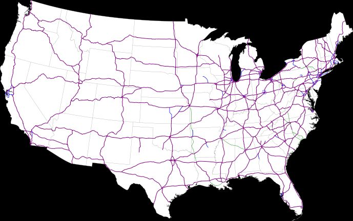
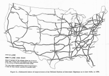
|
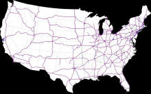
Interstate Highways in the 48 contiguous states. Purple routes
are currently built and open freeways, blue are currently open
auxiliary routes, and green indicates proposed routes, future
roads, or those currently under construction. |
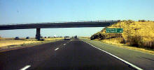
A rural stretch of
Interstate 5 in
California, with two lanes in each direction separated by a
large grassy
median, and with cross-traffic limited to overpasses and
underpasses. |
While Interstate Highways usually receive substantial
federal funding (90% federal and 10% state) and comply with federal
standards, they are owned, built, and operated by the states or toll
authorities. For example, the original
Woodrow Wilson Bridge (part of
Interstate 95/495),
was maintained by the federal government; its new span is now jointly
owned and maintained by the states of
Maryland and
Virginia.
There are also other Interstate Highways within the
District of Columbia, which is federal territory.
This freeway system serves nearly all major U.S. cities, with many
Interstates passing through
downtown areas. The distribution of virtually all goods and services
involves Interstate Highways at some point.
Residents of American cities commonly use urban Interstates to travel to
their places of work. The vast majority of long-distance ground travel,
whether for vacation or business, uses the national road network.
Of these trips, about one-third (by the total number of miles driven in
the country in 2003) use the Interstate system.
History
The Interstate Highway System was authorized by the
Federal-Aid Highway Act of 1956 –
popularly known as the National Interstate and Defense Highways Act of
1956 – on June 29. It had been lobbied for by major U.S.
automobile manufacturers and championed by President
Dwight D. Eisenhower, who was influenced by his experiences as a
young Army officer crossing the country in the
1919 Army Convoy on the
Lincoln Highway, the first road across America. Eisenhower also had
gained an appreciation of the German
Autobahn network as a necessary component of a national defense
system while he was serving as
Supreme Commander of the
Allied forces in Europe during
World War II.
In addition to facilitating private and commercial transportation, it
would provide key ground transport routes for military supplies and
troop deployments in case of an emergency or foreign invasion.
|
1955 Map: The planned status of U.S. highways in 1955, as a
result of the developing Interstate Highway System |
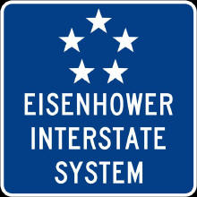
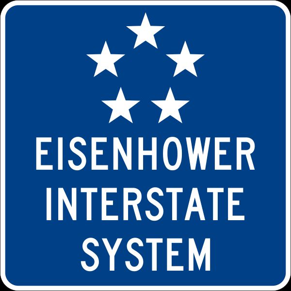
Commemorative sign introduced in 1993. Though the system was
established during Dwight D. Eisenhower's presidency, the five
stars commemorate his rank as
General of the Army during
World War II. |
Initial federal planning for a nationwide highway system began in
1921, when the
Bureau of Public Roads asked the
Army to provide a list of roads it considered necessary for national
defense. This resulted in the
Pershing Map.
Later that decade, highways such as the
New York parkway system were built as part of local or state highway
systems. As automobile traffic increased, planners saw a need for such
an interconnected national system to supplement the existing, largely
non-freeway,
United States Numbered Highway system. By the late 1930s, planning
had expanded to a system of new superhighways. In 1938, President
Franklin D. Roosevelt gave BPR chief Thomas MacDonald a hand-drawn
map of the U.S. marked with eight superhighway corridors for study.
In 1939, BPR Division of Information chief
Herbert S. Fairbank wrote a report entitled Toll Roads and Free
Roads, "the first formal description of what became the interstate
highway system," and in 1944 the similarly-themed Interregional
Highways.
The publication in 1955 of the General Location of National System of
Interstate Highways, informally known as the Yellow Book,
mapped out what became the Interstate System

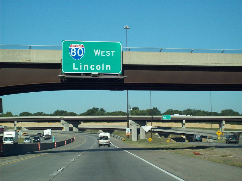
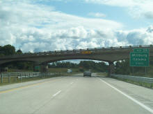
A stretch of I-80 in Omaha, Nebraska with a typical Interstate
reassurance sign with control city listed.
Although construction on the Interstate Highway System continues,
I-70 through
Glenwood Canyon (completed in 1992) is often cited as the completion
of the originally planned system.
The initial cost estimate for the system was $25 billion over 12 years;
it ended up costing $114 billion (adjusted for inflation, $425 billion
in 2006 dollars)
and taking 35 years to complete.
Additional spurs and loops/bypasses remain under construction, such as
Interstate 485 in
North Carolina, which has been under construction since the 1980s. A
few main routes not part of the original plan remain under construction,
such as
Interstate 22 in
Tennessee,
Mississippi, and Alabama,
and the extension of
Interstate 69 from Indiana
to Texas.
Officials have also identified some non-Interstate corridors for future
inclusion into the system, either by construction of new Interstate
routes or upgrade of existing roads to Interstate standards.
Due to the cancellation of the
Somerset Freeway,
Interstate 95 is discontinuous in New
Jersey. Authorized by the federal government in 2004, the
Pennsylvania Turnpike/Interstate 95 Interchange Project is scheduled
to connect the separate sections of I-95 to form a continuous route,
completing the final section of the original plan. Construction began in
2010.
Three states have claimed the title of first Interstate Highway.
Missouri claims that the first three contracts under the new program
were signed in Missouri on August 2, 1956. The first contract signed was
for U.S. 66. On August 13, 1956, Missouri awarded the first contract
based on new Interstate Highway funding.
Kansas claims that it was the first to start paving after the act was
signed. Preliminary construction had taken place before the act was
signed, and paving started September 26, 1956. The state marked its
portion of I-70 as the "first project in the United States completed
under the provisions of the new Federal-Aid Highway Act of 1956."
According to information liaison specialist, Richard Weingroff, the
Pennsylvania Turnpike could also be considered one of the first
Interstate Highways. On October 1, 1940, 162 miles (261 km) of the
highway now designated I-70 and I-76 opened between
Irwin and
Carlisle. The Commonwealth of Pennsylvania refers to the turnpike as
"The Granddaddy of the Pikes".
Nebraska was the first state to complete its mainline Interstate
Highway. The portion of
Interstate 80 in Nebraska was completed on October 19, 1974.
Standards
|
I-94 near Coloma, Michigan showing examples of Interstate
standards: rumble safety strips on shoulders, pavement type of
parallel grooved (tined) concrete, restricted overpass height
signage, secondary road overpass signage in center median, newly
FHWA instituted cable median barriers, and upcoming exit signage
on right shoulder |
The
American Association of State Highway and Transportation Officials (AASHTO)
has defined a set of standards that all new Interstates must meet unless
a waiver from the
Federal Highway Administration (FHWA) is obtained. One almost
absolute standard is the
controlled access nature of the roads. With few
exceptions,
traffic lights (and cross traffic in general) are limited to
toll booths and
ramp meters (metered flow control for lane merging during rush
hour).
Speed limits
Being
freeways, Interstate Highways usually have the highest
speed limits in a given area. Speed limits are determined by
individual states. From 1974 to 1987, the maximum speed limit on any
highway in the United States was 55 miles per hour (90 km/h), in
accordance with federal law.
Currently, rural speed limits generally range from 65 to 75 miles per
hour (105 to 121 km/h), although several portions of
I-10 and
I-20 in rural western Texas, along with a portion of
I-15 in rural central Utah, have speed limits of 80 mph (130 km/h).
Typically, lower limits are established in the more densely populated
Northeastern states, while higher speed limits are established in
the less densely populated
Southern and
Western states.
For example, some stretches of
I-76 through
Philadelphia have a speed limit of 50 mph (80 km/h). Also
interstate 68 in
Cumberland, Maryland has a speed limit of 40mph.
Other uses
As one of the components of the National Highway System, Interstate
Highways improve the mobility of military troops to and from airports,
seaports, rail terminals, and other military bases. Interstate Highways
also connect to other roads that are a part of the
Strategic Highway Network, a system of roads identified as critical
to the
U.S. Department of Defense.
The system has also been used to facilitate evacuations in the face
of hurricanes and other natural disasters. An option for maximizing
traffic throughput on a highway is to reverse the flow of traffic on one
side of a divider so that all lanes become outbound lanes. This
procedure, known as
contraflow lane reversal, has been employed several times for
hurricane evacuations. After public outcry regarding the inefficiency of
evacuating from southern Louisiana prior to
Hurricane Georges' landfall in September 1998, government officials
looked towards contraflow to improve evacuation times. In
Savannah, Georgia, and
Charleston, South Carolina, in 1999, lanes of Interstates
16 and
26 were used in a contraflow configuration in anticipation of
Hurricane Floyd with mixed results.
In 2004, contraflow was employed ahead of
Hurricane Charley in the
Tampa, Florida area and on the
Gulf Coast before the landfall of
Hurricane Ivan;
however, evacuation times there were no better than previous evacuation
operations. Engineers began to apply lessons learned from the analysis
of prior contraflow operations, including limiting exits, removing
troopers (to keep traffic flowing instead of having drivers stop for
directions), and improving the dissemination of public information. As a
result, the 2005 evacuation of
New Orleans, Louisiana prior to hurricane
Katrina ran far more smoothly.
A widespread
urban legend states that one out of every five miles of the
Interstate Highway System must be built straight and flat so as to be
usable by aircraft during times of war. Contrary to popular lore,
Interstate Highways are not designed to serve as airstrips.
Numbering system
Primary (1- and 2-digit) routes
The numbering scheme for the Interstate Highway System was developed
in 1957 by the
American Association of State Highway and Transportation Officials (AASHTO).
The association's present numbering policy dates back to August 10,
1973.
Within the continental United States, primary Interstates – also called
main line Interstates or two-digit Interstates – are assigned numbers
less than 100.
In the numbering scheme, east-west highways are assigned even numbers
and north-south highways are assigned odd numbers. Odd route numbers
increase from west to east, and even-numbered routes increase from south
to north, though there are exceptions to both principles in several
locations. Numbers
divisible by 5 are intended to be major arteries among the primary
routes, carrying traffic long distances.
Major north–south arterial Interstates increase in number from
I-5 between Canada
and Mexico
along the
West Coast to
I-95 between Canada
and
Miami along the east coast. Major west–east arterial Interstates
increase in number from
I-10 between
Santa Monica, California and
Jacksonville, Florida to
I-90 between
Seattle, Washington, and
Boston, Massachusetts, with two exceptions. There is no Interstate
50 or Interstate 60, as routes with those numbers would likely pass
through states which currently have
U.S. Highways with the same numbers, which is not allowed under
highway administration guidelines.
Two-digit Interstates in Hawaii,
as well as the "paper"
Interstates of
Alaska and
Puerto Rico, are numbered sequentially in order of funding, without
regard to the rules on odd and even numbers.
Several two-digit numbers are shared between two roads at opposite
ends of the country (I-76,
I-84,
I-86, and
I-88). Some of these were the result of a change in the numbering
system as a result of the new policy adopted in 1973. Previously,
letter-suffixed numbers were used for long spurs off primary routes; for
example, western
I-84 was I-80N, as it went north from
I-80. The new policy stated, "No new divided numbers (such as
I-35W and
I-35E, etc.) shall be adopted." The new policy also recommended that
existing divided numbers be eliminated as quickly as possible; however,
I-35W and I-35E still exist in the
Twin Cities of
Minneapolis and
Saint Paul, Minnesota, and the
Dallas-Fort Worth Metroplex in Texas.
AASHTO policy allows dual numbering in order to provide continuity
between major control points.
This is referred to as a
concurrency or overlap. For example,
I-75 and
I-85 share the same roadway in Atlanta;
this 7.4-mile (11.9 km) section, called the
Downtown Connector, is labeled both I-75 and I-85. Concurrencies
between Interstate and U.S. Route numbers are also allowed per AASHTO
policy, as long as the length of the concurrency is reasonable.
In rare instances, two routes sharing the same roadway are signed as
traveling in opposite directions; one such
wrong-way concurrency is found between
Wytheville and
Fort Chiswell, Virginia where
I-81 north and
I-77 south are equivalent, as are I-81 south and I-77 north.
Auxiliary (3-digit) Interstates
Auxiliary Interstate Highways are circumferential, radial, or spur
highways that principally serve urban areas. These types of Interstate
Highways are given three-digit route numbers, which consist of a single
digit prefixed to the two-digit number of a nearby primary Interstate
Highway. Spur routes deviate from their parent and do not return, with a
few exceptions; these are given an odd first digit. Circumferential and
radial loop routes return to Interstate Highways, and are given an even
first digit. Due to the large number of these routes, auxiliary route
numbers may be repeated in different states along the mainline. Some
auxiliary highways do not follow these guidelines, however.

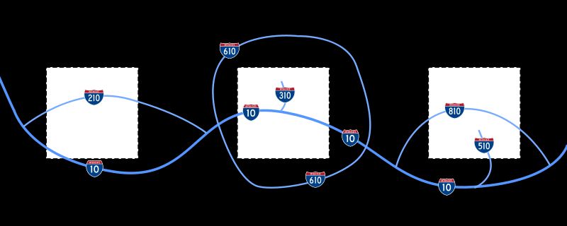
Examples of the auxiliary Interstate Highway numbering system
In the example above, City A has an even-numbered circumferential
highway. City B has an even-numbered circumferential beltway and an
odd-numbered spur. City C has an even-numbered circumferential highway
and an odd numbered spur. Because cities A, B, and C are in the same
state, each auxiliary route carries a distinct three-digit route number.
Unlike primary Interstates, three-digit Interstates are signed as
either west/east or north/south, depending on the general orientation of
the route, without regard to the route number. For some looped
Interstate routes,
inner/outer directions are used as a directional labeling system, as
opposed to compass directions.
Business routes
AASHTO defines a category of special routes separate from primary and
auxiliary Interstate designations. These routes do not have to comply to
Interstate construction standards, but are routes that may be identified
and approved by the association. The same route marking policy applies
to both U.S. Numbered Highways and Interstate Highways; however,
business route designations are sometimes used for Interstate
Highways.
Known as
Business Loops and
Business Spurs, these routes that principally travel through the
corporate limits of a city, passing through the
central business district of the city. Business routes are used when
the regular route is directed around the city.
Alaska, Hawaii, and Puerto Rico
The Interstate Highway System also extends to Alaska, Hawaii, and
Puerto Rico. Those in Hawaii,
all on the populous island of Oahu, carry
the designation of H-x (e.g.,
Interstate H-1) and connect military bases, though they are open to
public use. Both Alaska
and
Puerto Rico have public roads that receive funding from the
Interstate program, although these routes are not signed as Interstate
Highways (except on paper). These roads are neither planned for, nor
built to, official Interstate Highway standards.
Financing

I-787 in
Watervliet,
New York, showing the Exit 8
diamond interchange
In the lower 48 states, it is the system of highways
that travels interstate. There is not meant to be any implication that
each single- or double-digit numbered road travels interstate, as some
erroneously believe. As such, they are funded
federally with money shared among the states. The H-x
Interstates in Hawaii
and the paper interstates in Alaska and Puerto Rico are funded in
the same way as in the other states.
About 70% of the construction and maintenance costs of highways in
the U.S. are covered through user fees (net of collection costs),
primarily gasoline taxes collected by the federal government and state
and local governments, and to a much lesser extent tolls collected on
toll roads and bridges. The rest of the costs are borne by general fund
receipts, bond issues, and designated property and other taxes. The
federal contribution is overwhelmingly from motor vehicle and fuel taxes
(93.5% in 2007), as is about 60% of the state contribution. However,
local contributions are overwhelmingly from sources other than user
fees.
The portion of the user fees spent on highways themselves covers about
57% of costs, as approximately one-sixth of the user fees are diverted
to other programs, prominently including mass transit. In the eastern
United States, large sections of some Interstate Highways planned or
built prior to 1956 are operated as toll roads.
As American suburbs have expanded, the costs incurred in maintaining
freeway infrastructure have also grown, leaving little in the way of
funds for new Interstate construction.
This has led to the proliferation of toll roads (turnpikes) as the new
method of building limited-access highways in suburban areas. Some
Interstates are privately maintained (e.g., VMS maintains I-35 in Texas)
to meet rising costs of maintenance and allow state departments of
transportation to focus on serving the fastest growing regions in their
respective states.
Parts of the system may have to be tolled in the future to meet
maintenance and expansion demands, as has been done with adding toll HOV/HOT
lanes in cities such as
San Diego,
Salt Lake City,
Minneapolis,
Houston,
Denver,
Dallas,
Atlanta, though part of the tolling is an effect of the SAFETEA-LU
act, which has put an emphasis on toll roads as a means to reduce
congestion.
and
Washington, D.C. At present, federal law does not allow for a state
to change a freeway section to a tolled section for all traffic.
Toll Interstate
Highways
Approximately 2,900 miles (4,700 km) of toll roads are included in
the Interstate Highway System.
While federal legislation banned the collection of tolls on Interstates,
many of the toll roads on the system were either completed or under
construction when the Interstate Highway System was established. Since
these highways provided logical connections to other parts of the
system, they were designated as Interstate highways. Toll roads
designated as Interstate highways (such as the
Massachusetts Turnpike) were typically allowed to continue
collecting tolls, but are generally ineligible to receive federal funds
for maintenance and improvements.
Policies on toll roads and Interstate highways have since changed.
The
Federal Highway Administration has allowed some states to collect
tolls on Interstate highways, while a recent extension of
Interstate 376 included a section of
Pennsylvania Route 60 that was tolled by the
Pennsylvania Turnpike Commission before receiving Interstate
designation.
Signage
The majority of Interstates have
exit numbers. All
traffic signs and lane
markings on the Interstates are supposed to be designed in compliance
with the
Manual on Uniform Traffic Control Devices (MUTCD). However, there
are many local and regional variations in signage.
For many years,
California was the only state that did not use an exit numbering
system. It was granted an exemption in the 1950s due to having an
already largely completed and signed highway system; at the time,
placing exit number signage across the state was deemed too expensive.
Since 2002, however, California has begun to incorporate exit numbers on
all its freeways – Interstate, U.S., and state routes alike. To mitigate
costs,
Caltrans commonly installs exit number signage only when a freeway
or interchange is built, reconstructed, retrofitted, or repaired. The
majority of the exits along California's Interstates now have exit
number signage, particularly in rural areas.
In most states, the exit numbers correspond to the mileage markers on
the Interstates. However, on
I-19 in Arizona,
length is measured in kilometers instead of miles, in part because the
road runs south to the Mexican border. On most even-numbered
Interstates, mileage count increases from west to east; on odd-numbered
Interstates, mileage count increases from south to north. Some tollways,
including the
New York State Thruway and
Jane Addams Memorial Tollway, use radial exit numbering schemes.
Exits on the New York State Thruway count up from
Yonkers traveling north, and then west from Albany. On the Jane
Addams Memorial Tollway, mileage markers count up from
Chicago-O'Hare International Airport traveling west, which is the
starting point of the tollway.
Many northeastern states label exit numbers sequentially, regardless
of how many miles have passed between exits. States in which Interstate
exits are still numbered sequentially are Connecticut, Delaware,
Massachusetts, New Hampshire, New York, Rhode Island, and Vermont.
Maine, Pennsylvania, Virginia, and Florida followed this system for a
number of years, but recently converted to mileage-based exit numbers.
The
Pennsylvania Turnpike uses both mile marker numbers and sequential
numbers. Mile marker numbers are used for signage, while sequential
numbers are used for numbering interchanges internally. The
New Jersey Turnpike also has sequential numbering, but other
Interstates within New Jersey generally use mile markers.
There are four common signage methods on Interstates: One is locating
a sign on the ground to the side of the highway, mostly the right, and
is used to denote exits, as well as rest areas, motorist services such
as gas and lodging, recreational sites, and freeway names. Another
method is attaching the sign to an overpass. The two most common methods
involve overhead
gantries; they can be mounted either on half-gantries that are
located on one side of the highway, like the ground-mounted sign; or
full gantries that bridge the entire width of the highway and often show
two or more signs.
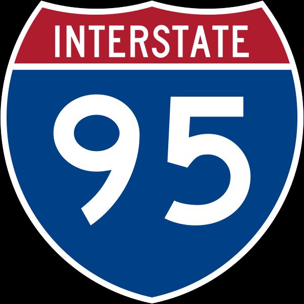
Interstate shield

Interstate Highways are signed by a number placed on a trademarked
red, white and blue
sign. A sample sign is shown to the right. In the original design,
the state was listed above the highway number, but in many states, this
area is now left blank. The sign usually measures 36-in (91 cm) high,
and is 36-in wide for two-digit Interstates or 45-in (114 cm) for
three-digit Interstates.

Interstate
business loops and
spurs use a special shield in which the red and blue are replaced
with green, the word BUSINESS appears instead of INTERSTATE,
and the word SPUR or LOOP usually appears above the
number. The green shield is employed to mark the main route through a
city's central business district, which intersects the associated
Interstate highway at one (spur) or both (loop) ends of the business
route. The route usually traverses the main thorofare(s) of the
city's downtown area or other major business district. A city may have
more than one Interstate-derived business route, depending on the number
of Interstates passing through a city and the number of significant
business districts therein.
Over time, the design of the Interstate shield has changed. In 1958,
the Interstate shield designed by
Texas Highway Department employee Richard Oliver was introduced, the
winner of a contest which included 100 entries;
at the time, the shield color was a dark navy blue and only 17-in
(41 cm) wide.
The
MUTCD standards revised the shield in the 1961, 1972, 1988, and 2000
editions. By 2000, the shield size had nearly quadrupled, with some
Interstate shields reaching 36 inches (910 mm) in width.